Q 1. Complete the sentences by choosing the right option :
(a) Brazil is covered mainly by …………………………… (March ’19 – ’22) (Textual)
(i) Highlands.
(ii) Plains.
(iii) Mountainous region.
(iv) Dissected hills.
Ans. Highlands
(d) Amazon is a large river in the world. Near its mouth ……………………………. (Nov. ’20; Sept. ’21) (Textual)
(i) deltaic regions are found.
(ii) no deltas are found.
(iii) deposition of sediments occurs.
(iv) fishing is done.
Ans. No deltas are found
The total coastline of India is ……….. km long. (Sept. ’21) (Non-textual)
(a) 7,100
(b) 7,400
(c) 7,700
(d) 7,500
Ans. 7,500
Q. Match the columns : (March ’22) (Non-textual)
Column ‘A’ Column ‘B’
Ans. (1) Pico-de-Neblina – Highest peak in Brazil.
Q. Are the sentences Right or Wrong?
The River Ganga originates from the Yamunotri glacier. (March ’19) (Non-textual)
Ans. Wrong
River Satluj is a major tributary of river Indus. (Sept. ’21) (Non-textual)
Ans. Right.
Q. Answer the following questions in one sentence each :
Which is the highest peak in Brazil? (Nov. ’20) (Nontextual)
Ans. Pico de Neblina is the highest peak in Brazil.
Q 2. Answer the following questions
(c) Explain the characteristics of the North Indian Plains. (March ’22) (Textual)
Ans. The characteristics of the North Indian Plains are as follows :
(1) A flat low-lying area is located in the north of India. This region is known as the North Indian Plains. (2) The North Indian Plains lie between Himalayan Mountain in the north and the Peninsula in the south. It extends from the states of Rajasthan and Punjab in the west to Assam in the east. (3) The North Indian Plains are divided into three parts. (4) The low-lying area to the east of the Aravalis is known as Ganga plains. It slopes to the east. (5) The delta of Ganga-Brahmaputra rivers extents in the state of West Bengal in India and Bangladesh. This region is known as Sunderbans. Sunderbans is the largest delta region in the world. (6) The western part of the North Indian Plains is occupied by desert. It is known as Thar Desert or Marusthali. The state of Rajasthan is occupied by Thar Desert. (7) The Plains of Punjab lies to the north of Thar Desert. It is located to the west of Aravalis and Delhi ranges. (8) The Plains of Punjab slopes to the west. It has very fertile soil and therefore, agriculture is highly developed in this region.
Write in brief about the Indian Island. (July ’19) (Non-textual)
Ans.
(A) Five major physiographic divisions of India are as follows :
(1) The Himalayas (2) The North Indian plains (3) The Peninsula (4) Coastal Plains (5) Island groups.
(B) The Indian Islands :
(a) Lakshadweep Islands :
(1) Lakshadweep Islands is a group of islands of India located in the Arabian Sea. (2) Lakshadweep Islands are to the southwest of the mainland of India. They are far away from the western coastline of India. (3) Most of the islands in Lakshadweep are atoll islands. (4) Most of the islands in Lakshadweep are tiny and low levelled.
(b) Andaman and Nicobar Islands : (1) Andaman and Nicobar islands are group of islands of India located in the Bay of Bengal. (2) Andaman and Nicobar islands are to the southeast of mainland of India. They are far away from the eastern coastline of India. (3) Most of the islands in Andaman group are volcanic islands. They are large in extent and have hilly regions in their interior parts. Most of the islands in Nicobar group are atoll islands. (4) Barren Island from Andaman group has the only active volcano in India.
Q 3. Write notes on
Western Coastal Plain. (July ’22) (Non-textual)
Ans. (1) Amazon river basin is the largest plain land of Brazil. It lies in the northern part of Brazil. The slope of Amazon river basin is to the east. (2) The width of Amazon river basin is the maximum, i.e. nearly 1300 km in the west. Its width is the minimum, i.e. 240 km where the Guiana Highlands and Brazilian Highlands come closer. (3) As the Amazon river approaches the Atlantic Ocean, the width of Amazon river basin/plains increases. (4) Amazon river basin/plains is covered by the evergreen tropical rainforests. Most of the area of Amazon river basin is inaccessible due to dense undergrowth and frequent flooding.
Q 4. Write geographical reasons.
(c) There are fewer natural ports on the eastern coast of India. (March ’19; Nov. ’20; July ’22) (Textual)
Ans. (1) The eastern coast of India is formed due to the depositional work of eastward flowing rivers meeting the Bay of Bengal. (2) Most of the western coast of India is a coast of submergence. On the other hand, eastern coast of India is a coast of emergence. As its effect, the sea is deeper in the west than the sea on the eastern coast. (3) Westward flowing rivers meeting the Arabian Sea form estuaries at many places on the western coast. On the other hand, eastward flowing rivers meeting the Bay of Bengal form deltas at many places on the eastern coast. As its effect, it becomes difficult for ships to reach the east coast covered with sediments. Therefore, there are fewer natural ports on the eastern coast of India.
Most of the Himalayan rivers are perennial in nature. (Sept. ’21) (Non-textual)
Ans. (1) Most of the Himalayan rivers originate in the snow covered southern heights of the Himalayan range. (2) These rivers are well fed by rains during the rainy season through the southwesterly monsoon winds. (3) These rivers are also fed by the melting of snow during summer. Therefore, most of the Himalayan rivers are perennial in nature.
Q 5. Identify the correct group
(b) These rivers of Brazil are north-flowing (July’ 19) (Textual)
(i) Juruika- Xingu- Aragua
(ii) Negro-Branco-Paru
(iii) Japura-Jarua-Purus
Ans. (a)
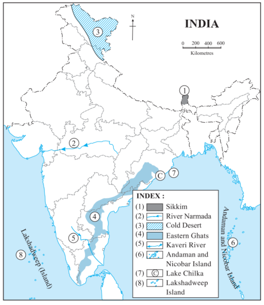
Q. Mark the following on a given outline map of India. Give index : (Non-textual)
(1) Sikkim (March ’22)
(2) River Narmada
(3) Cold Desert
(4) Eastern Ghats
(5) Kaveri River (July ’22)
(6) Andaman and Nicobar island (July ’22)
(7) Lake Chilka (July ’22)
(8) Lakshadweep Island (March ’22)
Ans.
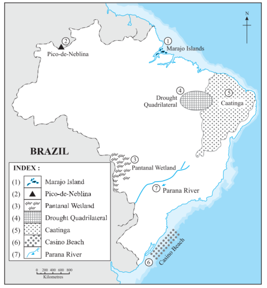
Q. Mark the following on a given outline map of Brazil. Give index : (Non-textual)
(1) Marajo Islands (March ’19)
(2) Pico-de-Neblina (March ’19; Sept. ’21)/ Highest peak in Brazil (July ’19)
(3) Pantanal Wetland (March ’19)/ Pantanal (Nov. ’20)
(4) Drought Quadrilateral (March ’19; Sept. ’21)
(5) Caatinga (March ’19)
(6) Casino Beach
(7) Parana River. (Sept. ’21)
Ans.