Standard 10 Geography question bank

Q1. Choose the correct option and complete the sentence:
1. Amazon basin is mainly _______.
    a) characterized by draughts        b) filled by swamps        c) covered by dense forests        d) fertile

2. One of the following is not useful for field visit:
    a) notebook             b) camera            c) map            d) ranging rod

3. The economy of Brazil is mainly dependent on ________ occupation.
     a) quaternary         b) secondary       c) primary       d) tertiary

4. In the north most region of India _________ forests are found.
     a) thorny             b) deciduous             c) Himalayan          d) evergreen

5. Brazil is famous for _________ dance.
     a) Samba      b) Bihu      c) Bhangra     d) Bharatnatyam

6. India ranks _________ in population in the world.
      a) first      b) fifth        c) seventh      d) second

7. Amazon is a large river in the world. Near its mouth _________.
      a) deltaic regions are found       b) no deltas are found            c) deposition of sediments occurs         d) fishing is done

8. In India, sparse network of railway is found in _________.
      a) Uttar Pradesh           b) Maharashtra          c) Tamilnadu          d) Rajasthan

9. These two countries in South America do not share their border with Brazil.
       a) Chile-Equador    b) Argentina-Bolivia       c) Columbia-French Guyana       d) Surinam-Uruguay

10. Both the countries have __________ type of government.
       a) military           b) communist         c) republic           d) presidential

11. India’s southern most point is known as _________.
       a) Lakshadweep       b) Kanyakumari      c) Indira Point          d) Port Blair

12. Rain forests of Brazil are known as _________.
       a) Mediterranean forests         b) Lungs of the world             c) World coffee pot           d) Roca

13. The economy of Brazil and India is of _________ type.
      a) backward          b) highly developed           c) developing            d) developed

14. Number of females _________ males in a region is known as sex ratio.
       a) percent            b) per lakh              c) per thousand            d) per million

15. Maximum part of Brazil is occupied by _________.
        a) highland        b) plain                   c) mountain                       d) dissected hills

16. Like India, Brazil also has _________.
        a) huge mountains       b) ancient plateaus         c) west flowing rivers        d) snow covered mountains

17. Amazon basin is mainly _________.
        a) drought prone          b) swampy              c) unfavorable for human settlements        d) fertile

18. Lakshadweep islands in Arabian sea are _________.
       a) dissected islands       b) coral islands     c) volcanic islands          d) continental islands

19. At the foot hills of Aravali _________ is found.
       a) Bundelkhand plateau       b) Mewar plateau           c) Malwa plateau     d) Deccan plateau

20. The concentration of settlements is related to which of the following major factors?
       a) proximity to coast             b) in plains                   c) availability of water             d) climate

21. Where do you find dispersed settlements in India?
       a) near the rivers            b)near the transport routes            c) hilly areas      d) industrial regions

22. Concentrated settlements are found in Narmada valley because of _________.
       a) forested land             b) cultivable land            c) undulating topography      d) industries

23. In north eastern part of Brazil ________ type of settlements are found.
       a) nucleated                   b) dispersed             c) linear              d) star shaped

24. Least urbanized state in Brazil is _________.
        a) Para            b) Amapa              c) Espirito Santo          d) Parana.

Q.1 Identify the correct group.
1. The order of physiographic units in Brazil while going from north-west to south-east.
a) Parana river basin- Guyana highlands- Brazilian highlands.
b) Guyana highlands- Amazon river basin- Brazilian highlands.
c) Coastal plains- Amazon river basin – Brazilian highlands.

2. These rivers of Brazil are north-flowing.
a) Juruika- Xingu- Aragua
b) Negro- Branco- Paru
c) Japura- Jarua_- Purus

3. The order of Plateaus of India from north to south. (* Ans according to – from south to north)
a) Karnataka- Maharashtra- Bundelkhand
b) Chhota Nagpur- Malwa- Marwad.
c) Telangana- Maharashtra- Marwad.

Q1. Identify the correct co-relation and complete the chain.

Ans.   1. India – New Delhi – Capital
           2. Samba – Dance type – Brazil
           3. Cricket – Popular game – India
           4. Position of lattitude – passes from centre of India – Tropic of cancer

Q1. Identify the correct co-relation and complete the chain

Ans.   1. North – French Gayana – North Atlantic
           2. East – Bangladesh – Bay of Bengal
           3. South – Sri Lanka – Indian ocean
           4. West – Pakistan – Arabian sea

Q1. Identify the correct co-relation and complete the chain.

Ans.   1. Coastal forest – Sundri – Soft, durable and oily wood
           2. Evergreen forest – Mahogany – Broad and evergreen leaves
           3. Deciduous forest – Teak – Trees shed their leaves
           4. Thorny and shrub forest – Khair -Short leaved tree

Q2. Identify the odd factor:
1. Forest type of Brazil:
a) Thorny and bushy forest
b) Evergreen forest
c) Himalayan forest
d) Deciduous forest

2. Forest type of India:
a) Mangrove forest
b) Mediterranean forest
c) Thorny bush type vegetation
d) Equatorial forest

3. Wild animal of Brazil:
a) Anaconda
b) Tamiarin
c) Red Panda
d) Lion

4. With reference to flora of India:
a) Deodar
b) Anjan
c) Orchid
d) Banyan

5. Major crops of Brazil:
a) Cocoa
b) Coffee
c) Soyabean
d) Jowar

6. Main purpose of field visit:
a) Geographical
b) Historical
c) Entertainment
d) Cultural

7. Salt producing states in India:
a) Gujarat
b) Rajasthan
c) Bihar
d) Tamilnadu

Q2. Match the following:
       

 Ans.  1. Evergreen forest – Pau Brasil
           2. Deciduous forest  – Teak
           3. Coastal forest    – Sundri
           4. Himalayan forest    – Pine
           5. Thorny and bush
               type vegetation    – Khejadi

Q2. Match the following:

Ans.  1. Manaus – Not much difference in the range of temperature
           2. Rajasthan – Low rainfall region
           3. Highlands of Brazil – Animals of grasslands
           4. North Indian Plains – Nucleated settlement         

Q2. Match the following: 

Ans.  1. Trans Amazonian route – Important transport route of Brazil
           2. Road transportation in India – Golden quadrilateral highway
           3. Rio de Janerio – Tourist spot

Q2. Answer the following questions as per the given instructions-
1. Arrange the following statements in proper order Preparation for field visit:
a) Visit to the place of field visit
b) Selection of the place
c) Report writing
d) Preparation for field visit
           i) B, D, A, C          ii) C, A, B, D           iii) D, A, B, C     iv) A, B, C, D

2. Identify the odd factor-
1) Indian tree
a) Deodar         b) Anjan         c) Orchid       d) Banyan

3. These rivers of Brazil are north-flowing.
a) Juruika – Xingu – Aragua
b) Negro- Branco- Paru
c) Japura- Jarua_- Purus

4. Arrange the given states of India according to distribution of population in descending order –
Himachal Pradesh, Uttar Pradesh, Arunachal Pradesh, Madhya Pradesh, Andhra Pradesh
Ans. Uttar Pradesh, Andhra Pradesh, Madhya Pradesh, Himachal Pradesh, Arunachal Pradesh.

5. Arrange the given states of Brazil according to distribution of population in ascending order –
Amazonas, Rio de Janerio, Amapa, Sao Paolo, Parana
Ans. Amapa,   Amazonas,  Parana, Rio de Janerio, Sao Paulo

6. Classify the following factors which affect on population, into favourable and unfavourable groups –

Proximity to the sea, Lack of roads, Temperate climate, Lack of industries, New cities and towns, Tropical humid forests, Minerals, Semi arid climate, Land favourable for agriculture

Ans. Favourable factors : Proximity to sea, Temperate climate, New cities and towns, Minerals, Land favourable for agriculture.
          Unfavourable factors : Lack of roads, Lack of industries, Tropical humid forests, Semi-arid climate. 

7. Which of the following shapes shows the coastal part of Brazil correctly?
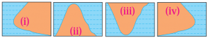
 

Ans. (i)

8. Compare and classify the population densities of area shown in 1 sq.km. of square in
     (A)  (a) and (b) each.  
     (B)  If in figure (b), one sign=100, then what will be the sex ratio?

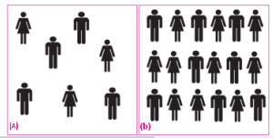
Ans. (A) In the fig. (a) density of population is 7 persons per sq. km. The region is sparsely populated.
                 In the fig. (b), The density of population is 18 persons per sq. km. The region is densely populated.

          (B) One sign = 100 persons
                 There are 10 female signs.
                ∴ Number of females = 100 × 10 = 1000
                There are 8 male signs
              ∴ Number of males = 100 × 8 = 800

∴ Number of females = 1000 × 1000 / 800
                                       = 1250

∴ Sex Ratio is 1250 females per 1000 males.

Q6.A) Prepare a simple bar graph with the help of given statistical information and answer the questions given below
Q6.B) Observe the following graph and answer the questions given below- 
PART 1 

PART 2

error: Content is protected !!